Monday, April 1, 2013

Take me back!

We all made it home last night, albeit a bit exhausted from our early start.  The trip was such an awesome opportunity and I have gained a new appreciation for the american southwest, geology, and mining.  Covering three national parks, four mines, two water treatment plants, four states, and nine hotels, we sure packed a lot in.  Thanks to everyone who made the trip a possibility!  And of course, this trip would not be complete without a new hand picked rock collection; our suitcases really were filled with rocks at the airport.


Check out my flickr photostream for a complete set of pictures.

Saturday, March 30, 2013

Taming the Colorado River

After experiencing the beauty of the desert and earth-made formations, our visit today consisted of learning about the Hoover Dam and the biggest man made lake in the entire world - Lake Mead.  We started off visiting St. Thomas, or rather the charred remains of this old town.  St. Thomas was founded in 1865 but after the Hoover Dam was constructed, the town became completely flooded by 1939.  Residents resisted until the waters were literally lapping at their doorsteps.  We were able to visit this town because the waters of Lake Mead have been receding for many years.


The graph above shows a consistent decline in the water volume since before 1998.  The remains of St. Thomas have been exposed since 2002 and we hiked into the valley to view the concrete bases of some major town buildings such as the school, ice cream parlor, and hotel.  Here is the terrascope group returning from our hike into the lake bed.  The current edge of Lake Mead is a few miles to the right of the picture:

Afterwards, we headed towards the Hoover Dam.  The drive was a bit longer than I expected but it clearly showed the magnitude of Lake Mead!  There was a great conversation in my van about lead in the environment as a tracer because of the percent composition of its four isotopes. My favorite parts of this trip were the intelligent side conversations that consisted of asking a lot a questions and learning about a variety of different earth science answers. There is so much out there to discover about our planet!
We stopped at an overlook near the edge of the receding waters of Lake Mead:


We finally arrived at the great Hoover Dam. The amount of concrete used in this endeavor was unimaginable.   It could be used to make a sidewalk around the entire equator of the earth!  The concrete would never have dried if it was just poured into this form, so the engineers put pipes in the concrete and pumped it full of cool water.  Then, they filled the holes with concrete.  But, the dam will still be cooling/chemically reacting for another 150 years.


The Hoover Dam generates hydroelectric power from the waters it retains.  It produces about 4 billion kilowatt hours of energy per year and provides this energy to a significant amount of Arizona, Nevada, and California.  Here is a picture looking from the top of the dam out to the "after" side.  The incredible dam bypass bridge is another concrete engineering wonder and is simply one of a kind.  After being deterred by wind, the bridge now rises 890 feet above the Colorado River after its recent completion.


We went inside the dam and saw the 17 generators that were turned by the water.  The lights on top of each one indicate whether it is on or not.

Here is a picture of Lake Mead from the top of the dam.  The white "bathtub rings" indicate water level.  At the highest point, the water would have reached the top of the rings.  Since the bleached band is so thick, its clear that the area is in a drought and the struggle for water in the desert will continue to increase.


I also got a few of my favorite images from the trip at Zion National Park yesterday.  Here are some sandstone rocks formed from sand dunes and the process of crossbedding and changing wind patterns overtime.


Here are some clouds rolling in:


A natural arch: 

A goat: 


And last but not least, our fearless leaders:


The Poets of Terrascope

From Dirk

The Earth here is moving, rocks folded and torn
Fault lines are showing; sediments worn
But Erin said it best "it's geologists porn"

From pizza to Chipotle, chicken to PB and jelly
Your belly never will be full, you'll just be full of belly

Eat your burrito and get in the van
We've got to leave Vegas as fast as we can

So many stories beneath the grey beard
All of the warning signs he never feared
No wonder we followed him even though he
Was the only one wand'ring where we weren't s'posed to be

I've heard there are only two things he likes:
    geology and surprises
He won't say where we'll travel each day
    but explains how each mountain rises
He usually knows where we're going (which
    is good 'cause none of us do)
But when he gets lost he will just keep on
    making those turns in the shape of a U

Her face lights up in wonder, there's a little squeal of glee
Every time we're looking at them architecturally
Just like Sam and Dwight love every rock and fault and ridge
Linda is ecstatic over every "sexy bridge"

We're MIT students, we can't go without
Puzzles + physics over break in the south
So with battleship bathtubs and monkeys and ice
Our "Safari Ari" is there to oblige

From Ana:
A Monument

The searing sun we felt that burned
it melted all the water
and so we swam in once-filled sea
white van tire rubber
We streaked more colors with our sweat
on already rainbow valleys--
Clayton, Paramint, Searles
and death
textures and layered color streaks
    slowly living, almost breathing
like ours, but wiser, weathering
We whisped by like smooth clay
and harsh sand sound together
all at once, symphony of crunch and dry
As single grains seeped through
impermeable shoes
infinite steps on formations of sand
These were the time-encrusted shapes we saw and made
And 8 letter "U"s we paved as well
    because it's Sam
    because he can
Wispy eyes searching for a giant gem, taking mostly rocks instead
Still, dying, monumental elements
vacation resort? no. time-constrained quest
finding what we search to find from habit
Soon we will leave, but the Southwest will keep
our steady gazes, questions, and echoing steps.

At the Gates of Zion and the Parting of the Water

So yesterday we went to Zion National Park.


Now that you've seen 1/10000000 of how awesome and beautiful Zion is (seriously, you should go for yourself) I can tell you about how cool it is geologically.

Zion is the middle step in something called the Grand Staircase, which is basically a staircase running through the Grand Canyon, Zion, and Bryce National Parks where the earth has been shifted up and the layers that make the top of the Grand Canyon are the same as the layers on the bottom of Zion, and the layers that make the top of Zion are the same as the layers on the top of Bryce. The Grand part comes from how beautiful the layers look, alternating limestone, sandstone, siltstone and mudstone in shades of red, orange, brown and gray.

These layers are the remnants of oceans, and then shallow seas in the area, as well as sand dunes in Zion's case. The crisscrossing patterns you see in the last photo above show some of this sand dune formation, as it was blown across a desert similar to the Sahara that crossed through several different states. There are several types of sand dunes, and using the cross-sections in the rock, geologists can estimate the size of the dune and speed of the wind moving the sand around. Based on things like the distance sand was blown over the tops of dunes, and the angles of its slope, these sand dunes were estimated to be 30 meters high and would need average daily winds of 52 mph! Seeing what was left was impressive enough. Also, if you look at the last picture again, you can see that the lines are cut off in places, indicating that the wind changed direction and thus changed the shape of the sand dune (and its cross-section). The sand probably all crystallized at once, due to silica and iron liquids cementing it together.

Zion is also beautiful because of the very distinct layering. We went on a hike up through the mountains, crossing through several of the layers (the Moenave and Navajo in particular). Each layer has distinguishing marks (although some could probably be easier lumped together by color than by time period) and some even contain dinosaur footprints and petrified wood!

We also got a look at Checkerboard Mesa where fractures in the rock created regular cracks that look like a checkerboard (sorry for the crappy shot, it was taken through the window of a moving vehicle).


We didn't have time to see much else, although we did get to buy souvenirs! I got two awesome books on petroglyphs, which are kind of like pictograms that Native Americans would draw on the walls. Two squiggly lines represent a canyon, and a black circle with a white cross symbolized the God of Life. Those are the few I remember, but I plan on learning them all. They reminded me in some ways of the hobo symbols used during the Great Depression to communicate food, lodging and danger.


(http://www.we-find-wildness.com/2010/05/hobo-signs/).


Anyway, Zion was exciting, and we all were exhausted by the time we finally went to bed. I personally fell asleep at 8.30 pm, which was weird and strange considering my MIT bedtime of 5 am.

Today instead of nature engineering we checked out some human engineering.
First we stopped at a town called St. George's, which was flooded by Lake Mead but now stands uncovered since the waters have dropped 30+ feet. It was a cute town, apparently fertile and awesome until Hoover Dam was installed and it was submerged. I didn't bring a camera on the hike so I have no pictures, but imagine cement foundations peaking out of sand, clam shells (from when the Colorado river flowed) and desert grasses.


The next stop was the Hoover Dam itself, where civil engineers delighted and danced around.

Dancing doesn't show up well in pictures.


We got a private tour through the underbelly of the dam, where we got to see the pipes used to divert water from the work area during construction. The pipes were so big (30 ft in diameter) that a plant had to be build to make them, since they couldn't be shipped.
Here's a layout of the dam during and after construction. The bottom, once water was diverted, was dredged up to 135 to get to the bedrock before building could begin. Then construction crews worked for 5 years, 363 days a year, filling in concrete blocks one at a time and cooling the concrete with cold water inside of pipes running through the blocks. This was the only way to get the concrete to set in time - otherwise it would have taken the concrete 150 years to cool. The dam was built with both time and money to spare; in the midst of the Great Depression. No wonder civil engineers love this place so much. 96 official deaths were reported during construction, but many more weren't recorded. Although the dam provides both water in the form of Lake Mead and hydroelectric power from generators powered by the Colorado River, the land flooded also covered towns and farms such as those at St. George's. More water is left standing, but over a wider surface area. Part of the trouble of large surface areas in the desert is the evaporation rate lowers the water by a lot. Overuse also has a lot to do with it. Hoover Dam and Lake Mead are partly so interesting because of their part in the challenge of water conservation in the Southwest, which may soon drive out people from cities like Phoenix and Las Vegas.


For my part, I'm just glad we can see these things without 30 meter sand dunes covering it all. Its been an amazing trip. Thank you Terrascope, and everyone in it, for making it so good.


Till then, cheers!

Thursday, March 28, 2013

When they say "non-potable", they mean it.

We started off the day at the water treatment plant where they filter all the wastewater coming out of Las Vegas. This enormous operation filters about 70 billion gallons of water per day! Below you can see us looking down at the aeration stage of the process, where "activated sludge" is bubbled to expose the water to air.


Our tour guide was a chemist who had worked at the plant for decades, and gave us very detailed and fascinating explanations of the entire process, and also described their plans for a new, more biologically-based process they may be transitioning to in upcoming years.

I was entertained by their ever-present warning signs against drinking the water:

After this huge plant, we moved on to the water treatment plant for Henderson, a smaller city neighboring Las Vegas. The overseer of quality-control for the plant showed us around this plant. Although he seemed rather surprised that we wanted a tour, and kept saying there "wasn't much to see", there was a LOT to see! We asked him lots of questions, including what the average flow was for a plant of this size, what their return rate was, and what they did with their solid waste.

This was more what I expected a water treatment plant to be like: lots of loud noises, big pipes, nobs and dials. Rin got ahold of the radio equipment and took sound samples of anything that buzzed, hummed or bubbled throughout the entire plant.

After the second water treatment plant we trekked to Moapa Valley, where a large Silica sand mine was waiting for us. We threw on some hard hats and, after a brief talk on the history of the mine and its main market, we were given a driving tour of the huge pit. Very fine, silica-infused sand is basically scooped off the surface here, and shipped to various companies for glass-making and other such production.


Processing here was pretty simple. We asked our guide if there were any byproducts of mining sand, and he just looked at us and responded frankly, "No." The sand is run through a series of conveyer belts, such as the one pictured above trailing off to the right, in order to get the right particle size. Then the sand is dropped off at the top of their tailings piles as shown below:


It was so straightforward, yet so big and majestic! Have I used that word in this blog yet? I probably have. Nevertheless, it was very impressive. Then we drove out of Nevada, through Arizona for a little while, and into Utah, where we are staying the night at a pretty classy hotel before we head off to the incredible sights of Zion National Park tomorrow. It's going to be epic, I can feel it.
Hasta luego!

Tincal (Tinkle) and Poo

On Tuesday, we visited the Rio Tinto borax mine - a huge open pit operation several hundred feet deep.  Most importantly, Borax is used in soap and glass.  Apparently, the roads into the mine get pretty slippery when wet, although this isn't a huge problem in the desert.  After receiving special safety instructions, we headed down into the mine, only to hear that they would soon be doing an explosion to blast some of the rock away using ammonium nitrite.  So we trekked back up to a better vantage point to get a good view.  Here is a before picture:


An after picture:


And some amused spectators:


Then we headed back into the mine to the bottom of the pit to view the raw materials.  There, we found three types of minerals: ulexite, kernite and tincal (pronounced like tinkle).  People had a lot of fun asking questions like "What color is tincal?" and "How much tincal do you produce?". Ulexite is interesting because it can be referred to as TV rock.  The mineral received this nickname because a pure piece of it will generate a double image.  Most of the borax-enriched minerals were white and some even sparkled in the sunlight.  The only rocks that deviated from this description were a few rare pieces that contained arsenic and were root beer-colored.
Here's an up close picture of kernite:


When the borax mine first opened in the late 1800s, 20 mule teams pulled loads of the material to the customers.  The mine had a cool representation of this in its museum parking lot.


On Thursday, we visited two wastewater treatment facilities in the Las Vegas and Henderson area.  The first we visited was mostly outdoors while the second was contained underground.  These trips were particularly interesting to me because I spent the last two summers working in my township's engineering department.  There, I sent out notifications to local facilities about the differences between sanitary and sewer drains in order to prevent pollution, so it was neat to see the actual process of sanitary sewage cleaning.  The smell wasn't great but the intricate and creative engineering made up for it.  After removing large solids, both sites used microbes to biologically clean much of the water.  The indoor site had these huge strings to clean the water that reminded me of baleen whales while at the other location it was interesting to see the algae that grew in the water, and the different colors throughout the plant.  See below.


Surprisingly, the wastewater comes into the plant as 99% water and 1% other materials, but its important to clean the water so fishing, swimming, and the environment can be protected at Lake Mead.  The 1% includes wrappers, pharmaceuticals, chemicals, and of course, poo.

And last but not least, here are a few of my favorite pictures of the American southwest from along our journey.

At the Oceanview mine in Pala, CA:


At the Las Vegas wastewater treatment plant:


And at the Simplot Silica mine in Overton, NV:


Wednesday, March 27, 2013

Mines mines mines

So to recap all I've not posted about:

We visited Searles Mineral Company in Trona, CA, where awesome pictures of salt flats and reflective lakes are taken:


Also they just mine all the world's hanksite and tons of borax and halite. Or something.

They are also very close to the planet Mars:


In all seriousness, Trona was an awesome place and had some really cool methods of reusing water, heat and electricity that seemed to be related to one man, Jim Fairchild. He was our charismatic tour guide, and very funny too. My favorite one liner (while talking about himself and his wife): 'We both have a speech impediment: we can't say no.' Great guy :)

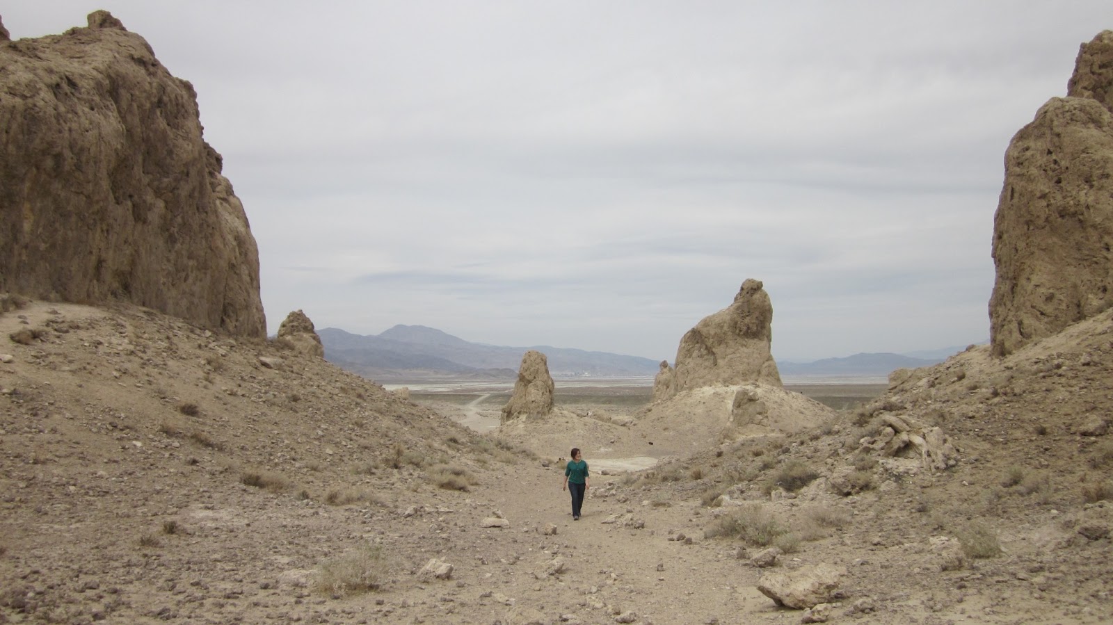
Like the lithium mine, Searles Mineral Co mined by pumping brine from a lakebed to the surface, where they processed it to get their products. The Mars landscape nearby is from algae formations on the edge of the same lake, which filled the valley 10,000 years ago. Its a popular site for movies.


Our next stop on Tuesday was Rio Tinto's giant borax mine. Patience has a much more detailed post so I won't try to repeat her, but here are some pictures of really cool rocks:

Sew kewl!!!!! OMG ROKCS!


Sam knows how to rock a hardhat.

Well we got lots of pretty samples and later that night I realized that I may have collected too many rocks (aghhhhh customs don't hate me):

And so our wearied travelers went onward, looking for new terrain. Really we just slept a night and then loaded up in the vans. But today was special, because for the first time, we saw GREEN.

 Desert on.

Desert off.


!!!!
GREEN!
Here's Linda blocking some green:


Just off Route 66 (weeooooooo) we stopped at Blue Cut fault line for Sam to show us another cool thing about geology. The fault line had exposed rocks that contained garnets in them, sticking out from the weathered rocks. The interesting part about this fault was it was actually that much easier to see for the weathering, versus when it had freshly formed. After a long time though, weathering erodes it away. So Goldilocks had it right, not too much and not too little, but rain on me justttt right.

The garnets are the darker bits that haven't been as weathered.


The rest of the trip was uneventful, except for the godly fish tacos we ate once we got to Temecula. Mmm Wahoo. If you're in Temecula, definitely go to Wahoo's and get fish tacos. Because who grills the most freshly caught wahoo? Wahoo, that's hoo! 
Then we had our first late rise and shine (8 AM :O) and got ready for some gem mining at Oceanview Mine. We were first instructed on how to mine the most efficiently (the idea being to move a lot of dirt while leaving no stone unturned) through the use of buckets, two screens, water and a careful eye. 


Gems mined here vary from common quartz to the rare kunzite, which is only found here and valued at priceless. Their two big finds (one of which is the Candelabra in the Smithsonian) are together valued at 32 million for insurance purposes. The mine found their minerals mainly in pegmatites, but they were varied and beautiful. I took home some nice aquamarines, tourmalines of various colors, a giant garnet and several lepidolites, a purple crystal containing up to 3% lithium (which gave it its color), the highest concentration you will find in a rock. 

(For a full list of their minerals, click here: http://www.gemandmineral.com/oceanviewmine.html)


The area was so pretty, it was just as spectacular to look up and see the mountains as look down and find a pretty pink crystal in your hand. 


We were also taken on tours of the mine underground, where we saw the pockets they had emptied of their gems. 


The pink clay was basically dissolved granite, which no one seemed to have a definite answer for its existence. It was everywhere though, alternating with lepidolite for attention.


We left the mine pretty early to get a headstart on our near 300 mile drive back towards Las Vegas. We stopped along the way to get a picture of the Molycorp mine at Mountain Pass, which we sadly could not go inside and visit. Funny how differently companies would respond to us.


I have a haiku from Kathryn again, that mirrors the motions of sifting through rock we went through today:

Sifting, panning, wait!
Tourmaline, or just mica?
Hopes rise, fall, again.